
How a late-October Atlantic storm changed character
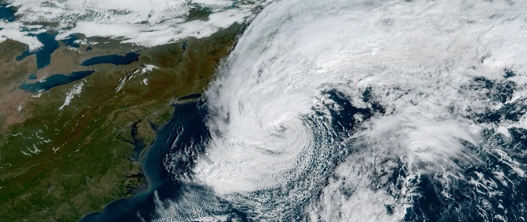
NOAA's GOES-19 satellite recorded a striking October weather system that began as a large nor'easter and acquired the name Subtropical Storm Josephine off the eastern United States. The National Environmental Satellite, Data, and Information Service published its illustrated account on 22 October 2026, using a GeoColor image taken at 10:26:22 UTC that day. For boaters, the notable lesson is not the name of the storm alone, but the breadth and arrangement of the wind-producing weather around it.
Josephine became a named subtropical storm late on 21 October, and the National Hurricane Center subsequently reported that it had become a powerful extratropical low by 22 October. The agency's final advisory was issued that Thursday, so this article is a review of a completed tropical-cyclone advisory sequence rather than a live forecast. A historical satellite photograph should never be treated as a current statement of safe conditions along the coast.
NOAA's operational satellite desk placed the post-tropical system near 40.0 degrees north and 65.8 degrees west at the time of the final advisory. The archived description gave maximum sustained winds near 65 mph, an important reminder that losing the tropical or subtropical classification does not automatically mean that a low-pressure system has lost its ability to produce hazardous weather. Classification and hazard level are related, but they are not interchangeable.
What GOES-19 could see from above
The released satellite photograph shows the large-scale architecture of Josephine and the surrounding North Atlantic weather. NOAA identifies the observing platform as GOES East, also known as GOES-19, and the image product as GeoColor from the Advanced Baseline Imager. The photo is a timestamped observation, not an artist's rendering and not a reconstructed depiction of what the sea looked like at deck level.
GeoColor combines different satellite measurements to present cloud patterns in an accessible way. During daylight it resembles visible-colour imagery, while after dark the system uses infrared information so that cloud fields remain visible. The product is valuable for seeing how separate bands and swirls are linked, but it does not replace measured local winds, waves, visibility, or an official forecast for a skipper deciding whether to leave harbour.
NOAA described dense cloud bands developing west of Josephine as another frontal system moved from the Great Lakes region and swept the storm northeastward over the open Atlantic. In the satellite image, this interaction is part of the story: the low was not an isolated round vortex simply drifting toward a single landfall point. Its circulation and frontal surroundings created a much broader weather picture than a simplified storm-centre marker can convey.
The Advanced Baseline Imager operates across visible and infrared spectral bands, allowing specialists to monitor cloud structure by day and night. Its imagery contributes to identification and monitoring of severe storms, but the satellite cannot directly tell a recreational skipper the exact short-period sea state at a particular buoy or inlet. Observing a dramatic cloud shield therefore begins the analysis; it should not end the passage-planning process.
Why subtropical and extratropical still matter to sailors
A subtropical cyclone shares some characteristics with both tropical and non-tropical weather systems. NOAA explains that a tropical storm takes much of its energy from warm ocean water, whereas an extratropical low draws heavily on contrasts between different air masses. A subtropical cyclone may draw on elements of both mechanisms, with wind and cloud patterns that are broader or less symmetrical than many familiar compact tropical-cyclone illustrations.
That distinction is operationally useful because a skipper can be hundreds of miles from the named storm's centre and still encounter its swell field or a different part of the surrounding weather system. NOAA reported substantial swells affecting the Eastern Seaboard and parts of Atlantic Canada during Josephine's development, alongside dangerous surf and rip-current conditions in exposed coastal areas. Those reports describe the event as it unfolded in October and are not current beach or marine warnings.
Storm categories can also change faster than an offshore boat's plans. When Josephine transitioned to an extratropical low on 22 October, that described its structure and energy source; it did not erase the winds or the existing wave field. An owner looking back at the weather archive should follow the sequence of official advisories rather than assuming the last change of label marks the moment an entire sea area became benign.
The National Hurricane Center's archived material records Josephine's formation and final post-tropical phase, while NOAA's satellite story describes how its cloud pattern helps explain the mixed characteristics. Together, they support a more complete view than either a still photograph or a single advisory headline. The facts also reinforce the need to distinguish conditions at a storm's centre from impacts that propagate well beyond it.
Practical lessons for offshore and coastal passage planning
A weather briefing for an autumn East Coast departure needs several layers. Begin with the latest official marine forecasts and any relevant watches or warnings, then look at the synoptic pattern, wave forecasts, local observations and expected conditions at the destination and any refuge ports. Archived images like Josephine's can train the eye to recognise large circulation patterns, but a live decision must rely on current operational products.
Distance on a screen can produce false reassurance. A storm centre plotted well offshore may be accompanied by swell reaching coastal entrances or by gusts associated with nearby fronts, especially where a vessel must cross a bar, round a headland or use a narrow inlet. Sea room and vessel size matter, as do the crew's experience, daylight availability and the ability to postpone. It is more useful to evaluate the whole route than to ask only how close the named low will pass.
Boaters should also understand the limits of the pictures they share. A static satellite image represents one instant, and visual cloud colour is not a direct scale of wave height. The NOAA STAR satellite site explicitly warns that some displayed satellite products are for information and should not be used as stand-alone operational forecasts or emergency guidance. Checking the product's date and limitations is part of using digital weather information intelligently.
Owners with modern multifunction displays, coastal weather apps and satellite receivers can compare multiple views of a developing system, yet these tools may draw on different forecast models and update at different intervals. Record when the forecast was issued and identify the official agency behind an alert. If connectivity is uncertain, download an appropriate briefing before departure and make sure the crew has a practical way to receive updated safety information while underway.
What the October record leaves behind
Josephine provides a clear example of how a named low can evolve quickly while its marine hazards remain serious. NOAA's 22 October satellite image captured the cloud shield during the subtropical stage, and the National Hurricane Center's final advisory later documented the change to a powerful extratropical system. The combination is more instructive than any claim that a particular cyclone type is automatically more or less dangerous to boating.
The original photograph accompanying this story is official GOES-19 imagery, not a generic storm picture. Its precise observation time matters: it records Josephine at 10:26 UTC on 22 October 2026 and must not be confused with current Atlantic conditions. Readers planning a passage should consult the National Hurricane Center, National Weather Service marine forecasts and their local coastguard advice for information relevant to the day they intend to sail.
Sources: NOAA/NESDIS, 'NOAA Satellites Monitor Subtropical Storm Josephine Off the East Coast' (22 October 2026); NOAA/NESDIS/STAR, archived AL102026 storm tracker and final National Hurricane Center advisory; NOAA/NESDIS/STAR, GOES-19 GeoColor product guidance. The original event records are available at NOAA NESDIS, NOAA STAR and the GeoColor product documentation.