
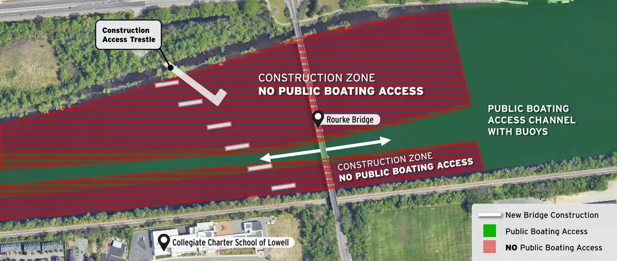
An October boating map for active bridge works
Boaters on the Merrimack River at Lowell, Massachusetts, face a defined navigation area during the Rourke Bridge replacement works. The state's Office of Fishing and Boating Access has published a warning for its Merrimack River boat-ramp users, while the Massachusetts Department of Transportation has released an updated public boating coordination plan for October 2026. Both notices emphasise keeping recreational craft away from the marked construction area.
The restriction is not a general shutdown of the Merrimack River. Public access remains possible through the designated corridor, but river users must respect the work-zone boundary and any on-water directions in place. For owners launching from a nearby ramp, the important change is that familiar water may now contain construction barges, temporary structures and a narrower route that demands more careful navigation.
Where recreational boats may pass
The Office of Fishing and Boating Access describes the permitted public channel on the southern bank of the Merrimack River. Its map shows a green area marked by a two-directional arrow, while a red-and-blue striped zone around Rourke Bridge is excluded because construction is underway. The state explicitly says boaters must not enter the striped area.
MassDOT's companion notice directs the public to stay within marked channel buoys between the UMass Lowell boathouse and the Rourke Brothers Memorial Boat Ramp. A boater should treat the visual map as a planning aid and the actual buoys, official signs and any valid navigation directions as the controls that matter on the water. The map itself is described as being for illustration and coordination, not as a navigation chart.
Why the channel is constrained this autumn
MassDOT reports that construction activity will continue in the river through autumn 2026. The work includes temporary pier cofferdams, which create contained areas in the water so foundations can be built, followed by preparation for future bridge piers. A cofferdam can occupy water space that recreational crews once regarded as open passage, so the restricted channel is tied to active engineering work.
The project website says work barges and equipment within the river have lights at their corners. That measure helps make the site visible but does not authorise passing inside a closed area or close to an anchored barge. Crews should be prepared for workers, service craft and shifts in the exact layout as construction progresses. Conditions at the site take priority over a screen capture of a map saved earlier in the season.
What the boat-ramp notice actually says
The state identifies two nearby access points in the Rourke Bridge advisory: Wooten Street in Chelmsford and Pawtucket Boulevard in Lowell. The public access page also separately lists Southwell Field on the Merrimack River at Wooten Street as open from 4 August 2026. That is a ramp-status notice, not a promise that every route beyond the slipway is unconstrained.
Before towing a boat to either site, owners should check for updated local access rules and available parking, then review the bridge map. A launch can be physically open while the approach to the preferred cruising area is restricted or slower than usual. Boat handlers using a launch for the first time should allow room in the schedule to study the site and establish a safe return route.
Passage planning for small recreational craft
In a temporary channel, simple seamanship becomes more important. Keep a useful lookout ahead and astern, slow sufficiently for the manoeuvring room available and avoid using construction equipment as a navigation reference. Boats travelling in opposite directions may need to coordinate their passage without creating wash or squeezing another vessel toward the exclusion boundary.
Skippers should decide before departure how they will respond if the channel appears obstructed, wind increases or visibility falls. A vessel that needs considerable width to turn may have fewer alternatives than a small outboard runabout. If the situation does not look safe, turning back to an authorised area is a valid and often prudent choice. Do not cross a barrier or enter the work zone simply to save time.
Construction activity is not confined to the water
MassDOT's autumn update also describes preparations and utility works on roads around the river, including Pawtucket Boulevard and approaches to the existing bridge. Some daytime road-lane reductions and short-term closures may affect the route used by vehicles and trailers. A mariner's trip planning should therefore begin before the boat reaches the ramp.
A trailer combination may need more turning space than a car, especially when diversion signs or working vehicles restrict the road. Checking current traffic advisories can help prevent late arrival and rushed launching. This is especially relevant when a crew has a short daylight window and the return journey must still allow time to recover the boat and secure its equipment.
How to read the official maps responsibly
MassDOT's October boating coordination plan is a valuable illustration of the work area and the channel that is intended to remain open. The state cautions, however, that such maps are for illustration and coordination only. They should not be treated as substitutes for maintained charts, current local notices or the instructions attached to buoys and markers actually encountered on the river.
Boat crews should check that they are consulting the latest map and update immediately before using the Merrimack near the bridge. Contractors may move equipment as a construction phase advances, and conditions can change after an article is published. Any uncertainty about the marked route deserves a call to the relevant public authority rather than an improvised passage close to a structure.
The practical message for Merrimack River boaters
The immediate message is specific: Rourke Bridge remains an active construction zone during autumn 2026, and recreational boating access is confined to the officially designated route. The Office of Fishing and Boating Access provides the ramp and channel notice, while MassDOT's construction update supplies the October coordination map and information about engineering activities.
Boaters using the river near Lowell can still plan a trip, but should make the designated corridor central to their route, give working equipment a generous margin and allow extra time at either end of the day. The safest launch is one supported by up-to-date information, a capable crew and a willingness to postpone a passage if the conditions at the marked route have changed.