
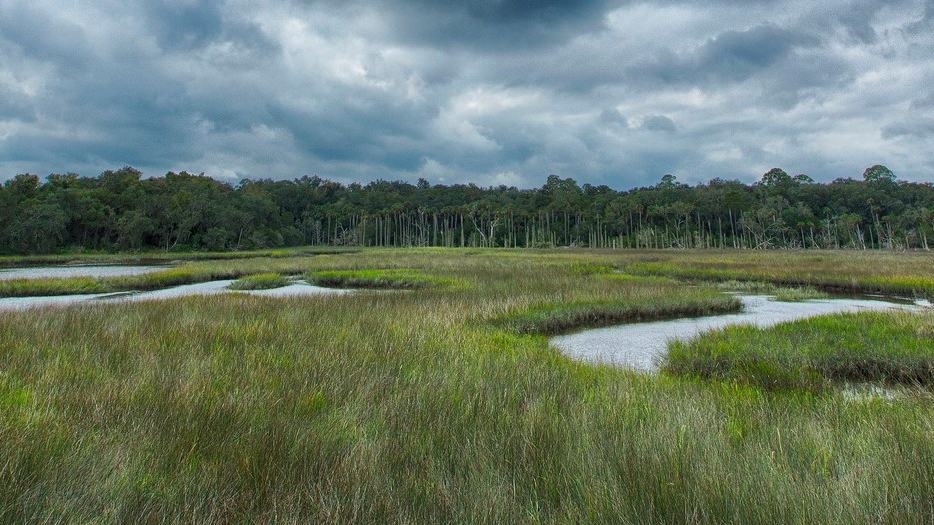
Timucuan Ecological and Historic Preserve offers saltwater paddling in tidal creeks and marshes near Jacksonville, where understanding the tides is central to a safe visit.
A tidal wilderness close to Jacksonville
Timucuan Ecological and Historic Preserve contains an extensive coastal landscape of creeks, marshes and barrier islands in northeastern Florida. Although the surrounding region includes busy urban areas and transport routes, the water between marsh grasses can feel remarkably quiet from a kayak. A slow paddle encourages visitors to notice birds, fish and the movement of the tide.
The National Park Service describes more than three quarters of the preserve's 46,000 acres as salt marsh estuary. That helps explain why water-based exploration is such a defining part of the visitor experience. It also means navigation is influenced by tide and current rather than by a fixed arrangement of easy inland paths.
Follow tidal creeks rather than an imaginary straight route
The preserve's creeks twist through low banks, and the apparent distance between two places can be deceptive. A narrow waterway may curve repeatedly before opening into a larger river or sound. Paddlers should use suitable charts or trail maps and confirm how to return to the correct launch rather than relying on the direction of a distant landmark.
Estuaries are particularly easy to misread when the tide changes. A channel that carries ample water near high tide may become shallow or expose mud at a later stage. The most comfortable plan allows time to travel before the level drops to a point where the boat may have to be carried.
Tide tables matter more than a pleasant forecast
The Park Service emphasises that understanding tides is fundamental to paddling in the Timucuan estuary. A rising or falling tide creates currents that can help or hinder progress, and the timing of high water varies by location. Simply knowing that high tide occurs in Jacksonville at a certain hour may not describe conditions in every smaller creek.
Visitors should consult current local predictions and understand the direction in which water is moving along the route. Wind can alter the experience further, especially on open stretches. A safe trip plan accounts for the return leg instead of assuming that a seemingly easy outward glide can always be repeated in reverse.
Birdwatching rewards quiet boat handling
Ospreys, herons and other birds use the waters and marsh edges, while small fish can sometimes be seen close to the surface. The park's descriptions highlight how quiet paddling allows visitors to enjoy wildlife without the noise of powered craft. A patient observer may gain more from a short stretch of creek than from attempting to cover a large distance.
Wildlife should never be pursued or approached in a way that disrupts feeding or nesting. Stop paddling where it is safe, allow animals room and use binoculars instead of trying to draw the kayak alongside a bird. The best observation usually comes when the paddler blends into the environment without disturbing it.
Choose an appropriate launch and equipment
The National Park Service provides paddling trail information and maps for the Timucuan area, including routes associated with the Florida Sea Islands Paddling Trail. Some trailheads provide useful access while others require more careful planning because of the tide or the nature of the bank. Choose a launch that suits the craft and the group's experience.
An open recreational kayak, a touring kayak and a canoe can behave differently in wind and current. Paddlers should understand their craft's stability, carrying capacity and recovery methods. A group should not attempt a longer estuary route merely because the boats are available to rent.
Small preparations make a significant difference
Check that the boat is in sound condition, with secure bulkhead covers or hatches and correctly fitted equipment. Carry appropriate personal flotation, a signalling device, drinking water and a reliable means of communication. Protect important items from immersion, including any map or route information needed to find the return launch.
Footwear should suit a wet landing, but do not assume that walking across mudflats is an easy alternative to paddling. Soft estuary mud can be difficult and dangerous to cross. A route that depends on carrying heavy boats across an exposed mud bank should be reconsidered before leaving shore.
Cross larger channels with care
The Timucuan area includes waterways that may carry powered boats, fishing craft or other traffic. A kayak is small and often difficult to see among reflections and marsh vegetation. Maintain a lookout, avoid obstructing marked routes and cross wider channels only when there is adequate time and visibility.
A group should keep enough separation to manoeuvre while remaining close enough to communicate. Nobody should be left behind to struggle against the current or wind. If visibility falls, it may be necessary to seek an appropriate landing or shorten the trip, rather than continuing toward an unfamiliar channel.
History adds context to the marsh
The preserve protects landscapes associated with Indigenous communities and later European settlement, including important historical sites such as Kingsley Plantation and the Fort Caroline area. A paddler travelling quietly through the estuary can reflect on how people have depended on waterways for transport, food and local knowledge across different periods.
Historical associations do not grant permission to land anywhere or explore protected remains. Visitors should use official access arrangements and respect closures. If a cultural destination is part of the plan, check whether it can actually be reached from the chosen boat route before promising it to the group.
A satisfying half-day route is enough
A first visit can focus on one accessible creek and its surrounding marsh habitat. Allowing time for wildlife observation and the tide makes the day enjoyable without turning it into a race. The proposed distance should reflect the slowest participant and the current conditions.
Tell someone ashore where the paddlers intend to travel and when they expect to be back. If the forecast worsens or the current proves stronger than expected, turn around while an easy return is still possible. Good judgement often means finishing a memorable outing early rather than reaching the farthest planned point.
Check park information before each visit
Use the park's paddling maps, current tide and weather forecasts and any local access notices. Conditions can vary by creek and season, and static route information cannot guarantee a safe journey on a particular day. Local paddling instruction can also help people unfamiliar with tidal estuaries.
Timucuan's salt marshes are best enjoyed by visitors who understand the water's changing character. A carefully chosen route offers an opportunity for quiet exploration close to a major city while protecting wildlife and leaving the delicate shoreline undisturbed.
Source
National Park Service