
Sleeping Bear Dunes National Lakeshore offers choices between gentle river floats, peaceful inland lakes and more demanding sea-kayaking on Lake Michigan.
An unusually broad choice of waterways
Sleeping Bear Dunes National Lakeshore in Michigan offers much more variety than a single famous stretch of shoreline. Visitors can paddle sections of the Platte and Crystal rivers, explore selected inland lakes or venture onto Lake Michigan when conditions and experience make that appropriate. The different settings allow a holiday to be adapted to the group rather than assuming that every outing must take place on an exposed lake.
The National Park Service emphasises that not all of these experiences require the same skills or equipment. A gentle family float on a suitable river is a very different proposition from a sea-kayaking journey beneath high bluffs. Choosing the right route is therefore the beginning of the trip, and a calm alternative should remain available if the bigger lake becomes unsuitable.
The Platte River for a leisurely introduction
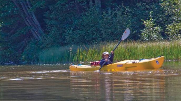
The Platte River flows through the southern part of the park and is popular for canoeing, kayaking and tubing. Equipment can be rented around its crossing of M-22, making a short river outing feasible for visitors travelling without their own boats. The official NPS photograph shows a young paddler enjoying the river, connecting the destination to a genuine small-craft scene.
Even an accessible route benefits from checking water levels and the expected time between launches and take-outs. Families should ask the rental provider what is included and whether the route is suitable for younger passengers. A good introduction allows people to practise handling their craft before encountering faster water or a crowded section.
Crystal River and changing levels
Near Glen Arbor, the Crystal River provides another peaceful paddling option, with rental businesses serving visitors to the northern part of the national lakeshore. The river flows toward Lake Michigan through scenery that can include wildflowers and wading birds. The Park Service cautions that low water sometimes makes canoeing difficult, so the season's conditions influence whether a trip can proceed easily.
A canoe touching bottom repeatedly can make an outing slow and tiring, and dragging it across sensitive areas may damage habitat. Visitors should ask about current river levels and follow instructions about where to launch and disembark. A shorter suitable journey is preferable to forcing a heavily loaded craft along an inadequately deep channel.
Twenty-six inland lakes create alternatives
The national lakeshore includes twenty-six inland lakes, some of which offer attractive kayaking and wildlife observation. The NPS highlights Loon Lake near the Platte River, along with School Lake and Bass Lake North. Loon Lake has a public access point off M-22 and an accessible kayak launch, making it worth investigating for visitors seeking a convenient place to paddle.
Each lake can have different restrictions and access conditions, and local information should govern the choice. Birds such as loons, ducks and swans may be observed from the water, but paddlers should keep enough distance to avoid disturbing feeding or nesting behaviour. A sheltered lake can remain enjoyable when Lake Michigan's wind and waves rule out a coastal outing.
Lake Michigan is a different level of challenge
The park protects more than thirty-five miles of sandy shoreline, with dunes and glacial bluffs rising as much as five hundred feet above the lake. A sea kayak can provide striking views that are difficult to appreciate from land. The scenic reward is substantial, yet Lake Michigan is large enough to generate dangerous conditions for an inexperienced paddler.
The Park Service warns about cold water, high winds, fog and rough seas, all of which can appear despite an inviting morning. A marine forecast should be checked before departure, with careful observation continuing throughout the outing. Kayakers are advised to remain relatively close to shore, allowing a reasonable chance of reaching land if something goes wrong.
The Manitou Islands are not a casual excursion
North and South Manitou Islands may tempt visitors looking at a map, but the NPS warns that the nearest crossing from the mainland is approximately eight miles, without intermediate places to stop. It also crosses a major shipping lane used by freighters and other vessels. Such a journey calls for experienced sea kayakers with recovery skills and a realistic plan for open-water conditions.
For those wishing to paddle around an island, transporting a kayak by an authorised ferry may be a safer alternative to making the crossing independently. That arrangement still requires appropriate equipment and an understanding of local sea conditions. A visitor should never treat the presence of a ferry or a scenic photograph as proof that a particular route is easy.
Equipment and communication
The NPS recommends a personal flotation device for each person and appropriate sound signalling equipment. For outings in restricted visibility or after dark, navigation lights and visual distress equipment may also be required. The specific equipment should match the craft, location and applicable rules, and the crew must know how it works before setting off.
A marine VHF radio can be useful on Lake Michigan, with Channel 16 available for emergency contact. A phone in a suitable waterproof container may provide an additional means of communication, but coverage can be inconsistent. Travellers should identify their location clearly if requesting help, especially near areas where the phone might connect through a distant state.
Float plans and invasive-species care
The Park Service encourages paddlers to leave a float plan with a trusted person, including their route, equipment, group and expected return. It does not itself monitor individual float plans, so somebody ashore must understand what to do if the party does not come back as arranged. Such preparation can be valuable even on an apparently ordinary afternoon.
Boats and related equipment also need to be cleaned, drained and dried when moving between waterways to reduce the spread of aquatic invasive species. This is particularly important for the park's smaller inland lakes. Simple decontamination habits help protect wildlife and the water quality that makes these settings attractive.
Choosing the right version of the holiday
A family could enjoy a day on the Platte River, a calm morning on Loon Lake and time exploring the dunes from shore without attempting any exposed crossing. More experienced paddlers may consider the Lake Michigan coastline when conditions support it. Each approach reveals a different side of the same national lakeshore.
The NPS's current paddling guidance, local rental operators and official forecasts should determine the itinerary. A genuine photograph of a young kayaker on the Platte River reflects one accessible possibility, but not every section of the park is equally forgiving. The most enjoyable holiday is one that matches the environment to the paddlers rather than the other way around.