
An independent, National Park Service-sourced private-boating guide to Santa Cruz Island, with Scorpion Anchorage, protected shorelines, NPS and Nature Conservancy landing rules, hiking options and practical crossing safety.
A different kind of Channel Islands arrival
Santa Cruz Island is not a conventional Californian weekend anchorage with a marina, fuel dock and a promenade waiting behind the breakwater. It is a rugged offshore landscape within Channel Islands National Park, approached across busy open water and visited on the terms set by weather, swell and conservation rules. For competent private-boat crews, that separation from the mainland is its great appeal: a genuine island journey rather than a routine waterfront stop.
Scorpion Anchorage on the eastern part of Santa Cruz is a particularly compelling first objective because a day ashore can combine a working maritime viewpoint, traces of island ranching and established hiking routes. The National Park Service describes Santa Cruz as the largest of the Channel Islands, but the scale of the island should not mislead newcomers into treating every cove as an accessible public landing. Ownership boundaries and sea conditions both shape what a responsible itinerary can include.
Assessing the crossing before committing
The Santa Barbara Channel can change character rapidly, sometimes within the same day. The park warns that currents, shifting swell, fog and strong wind challenge inexperienced crews and that the route passes commercial shipping lanes. A trip plan should be built around a suitable vessel, practiced watchkeeping and the latest marine forecast, with an unambiguous decision point at which a deteriorating outlook means postponing the landing rather than pressing on.
Channel crossings deserve more preparation than entering a sheltered harbor. A navigator should use current NOAA charts, plot shipping-lane crossings, assess visibility and confirm crew roles before clearing the mainland. The Park Service lists NOAA chart numbers 18720, 18721, 18725, 18727, 18728, 18729 and 18756 as useful regional references. These are chart references for planning, not a substitute for a plotted position, live navigation information or local notices.
Scorpion Anchorage and the limits of public facilities
At Scorpion Anchorage, the most important distinction is between an island landing and a protected berth. The park specifically states that it offers no public moorings and no all-weather anchorages around the islands. Its advice is to keep someone aboard the boat at all times, a significant consideration for a small crew whose members may all hope to hike together. Build the shore-party size and watch rotation around that constraint.
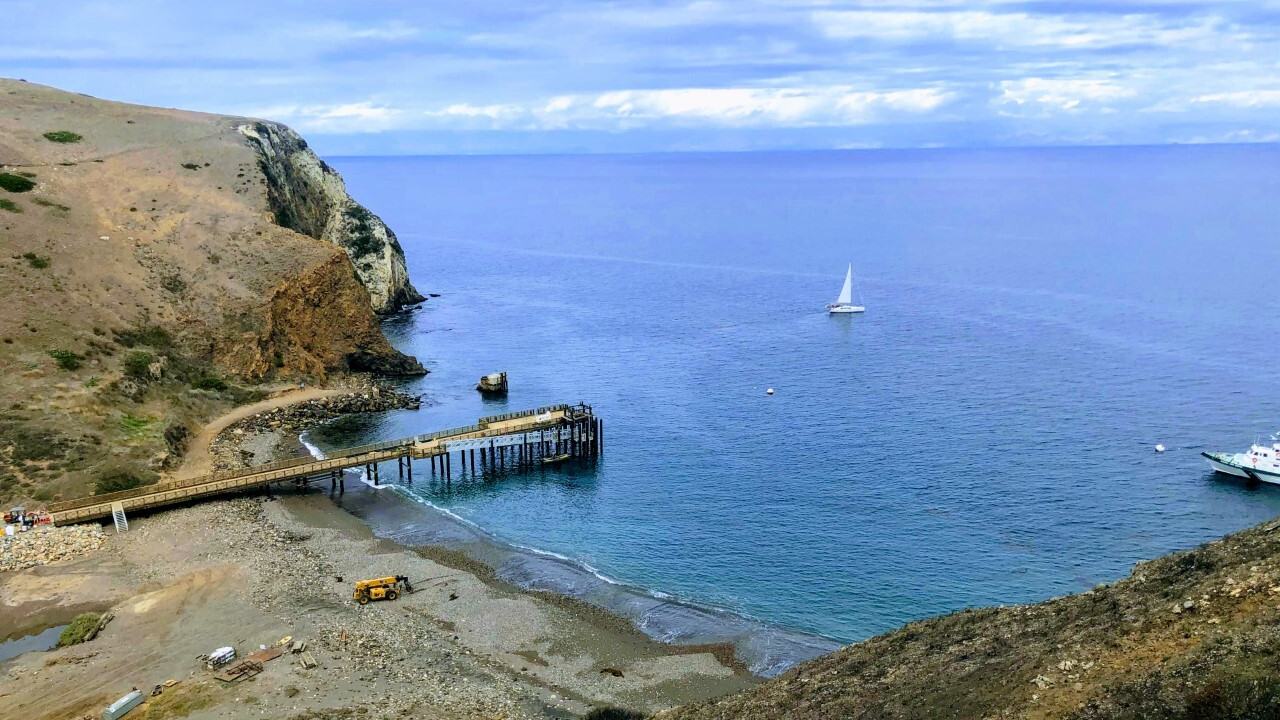
The official National Park Service photograph accompanying this guide looks down on the Scorpion Anchorage pier and water, with a sailboat offshore and the park vessel Ocean Ranger near its mooring. The scene explains the attraction without suggesting that any mooring visible in a photograph is available to visitors. Recreational crews need to follow the published landing procedures, maintain clearance from reserved government facilities and treat an unoccupied-looking location as unavailable until its status is confirmed.
Where private boaters may land
Santa Cruz Island has a split-management arrangement that matters on every shore excursion. The National Park Service says boaters may land without a permit on the eastern 24 percent of the island that it administers. The other 76 percent belongs to The Nature Conservancy, which requires a landing permit and charges a fee; its permit system also prohibits overnight island use. A crew should identify the ownership boundary before choosing a beach or planning a long inland walk.
The park identifies Scorpion Anchorage and Prisoners Harbor as places with piers, while warning that no visitor mooring buoys are available. It also restricts landings along the shoreline between Arch Point and the eastern edge of Potato Harbor to protect nesting seabirds. A permit-free visit to the NPS side is not a license to land anywhere along that shore. Check current posted restrictions and ask a ranger for an island orientation whenever possible.
Choosing a safe shore transfer
An exposed island landing begins well before anyone steps off the tender. The crew needs to assess the actual swell at the chosen approach, wave reflection near rocks, tide, boat motion and the likelihood that conditions will worsen before collection. The NPS urges extreme care with surf landings, particularly around Smugglers Cove and several south-facing beaches. If tender access is unsafe, the correct alternative is to stay offshore or return another day.
A modest shore party with personal flotation equipment, appropriate footwear and a dependable pickup arrangement can be safer and more enjoyable than an ambitious plan relying on a marginal landing. Avoid blocking the approaches used by park craft or concession vessels, and keep the mother boat's operator free to manoeuvre. Guests should understand in advance that the itinerary may be shortened or cancelled for a safe return to the vessel.
The easy cultural walk through Scorpion Ranch
Visitors who can safely land at Scorpion Beach have immediate access to the Scorpion Ranch historic area. According to the park's walking guide, a short route of about half a mile round trip leads through remnants of an agricultural complex established in the late nineteenth century. The setting includes a former ranch house now used as a visitor centre, a blacksmith shop, farm implements and interpretive features that give context to the otherwise wild-looking coast.
The island's ranching story adds welcome depth to a cruising excursion. After generations of Indigenous maritime life, European and American entrepreneurs developed livestock and agricultural operations in this remote environment. Remnants of roads, masonry and ranch buildings testify to the challenges of living and working across a water gap from the mainland. A careful visit can acknowledge this layered history without presenting the coastline simply as a pristine playground.
Cavern Point for a broad Pacific panorama
The park identifies its Cavern Point Loop as a moderate walk of roughly two miles round trip from Scorpion Beach. The circuit climbs above the anchorage to coastal viewpoints where the island's steep edges and wide horizons help visitors understand the surrounding seascape. Seasonal wildlife viewing may add interest, but birds and marine mammals should be observed from an appropriate distance rather than pursued for photographs.
Cavern Point also offers a useful practical lesson: the passage from the landing to an exposed headland may feel straightforward while the return route still demands water, sun protection and enough daylight. The NPS advises taking the loop clockwise from the campground to avoid a particularly steep climb. Crews planning a single-day call should reserve ample time for the descent, the collection by tender and an early departure if afternoon winds strengthen.
Potato Harbor is a viewpoint, not a beach shortcut
Another appealing walk follows the coast toward the Potato Harbor overlook. The National Park Service lists the round trip from Scorpion Beach at approximately five miles with a moderate difficulty rating. The reward is a landscape of headlands and a sheltered-looking inlet, but the agency is explicit that there is no beach access from the overlook. Reaching that viewpoint on foot does not create a lawful or practical route down to the water.
For visiting boaters this distinction prevents an inconvenient mismatch between a planned pickup and the reality of the trail. If the group leaves on foot from Scorpion, plan to return to the same approved landing unless a separate safe and permitted water access has been agreed. The photographable cove may tempt guests into improvisation; the itinerary should be based on the park map and actual landing rules instead.
Prisoners Harbor and the island's deeper history
Prisoners Harbor offers another window into Santa Cruz Island's cultural landscape, with historic structures, a restored wetland and opportunities to look for the endemic island scrub-jay. The NPS describes a short walk in the harbor vicinity of about half a mile, although a comfortable outing still requires suitable shoes and attention to changing ground conditions. The harbor should be assessed as its own landing operation, not assumed to offer the same conditions as Scorpion.
The larger story stretches well beyond the ranch era. National Park Service research records Chumash habitation of Santa Cruz Island over thousands of years, with coastal villages, maritime trade and specialized shell-bead production. Later ranching changed the island's ecology and built environment. A well-informed visitor can appreciate the island's protected landscapes while recognising that its history includes sustained human ingenuity, displacement and environmental change.
Sea caves, marine life and respectful distances
Sea caves along the island's coast are beautiful but can be lethal when a swell suddenly fills the opening. The National Park Service warns explorers to use extreme caution, recommends helmet protection and directs them to current closure rules. Kayak photography is no excuse to paddle into a confined cave during a rising sea. For most general recreational boaters, observing cliff lines and cave entrances from a safe offshore position will offer the more sensible experience.
Look also for the less spectacular details that make the Channel Islands biologically distinctive: kelp habitats, coastal birds, island vegetation and signs of the island fox's recovery. Wildlife is best experienced without feeding, chasing or crowding animals. A shore visit should leave no food waste, packaging or gear behind, while boat operators avoid disturbing fragile nearshore habitat with careless anchoring or repeated close passes.
What a self-sufficient boat needs aboard
The isolated setting rewards simple but thorough preparation. Carry sufficient drinking water, food, weather protection, first-aid supplies and communication equipment, and do not rely on mobile coverage when arranging a return. The park's hiking advice notes the absence of reliable mobile telephone and Wi-Fi service, and encourages downloading its visitor materials before departure. The helm should maintain an independent navigation and weather-monitoring capability throughout the visit.
A float plan should identify the crew, craft, route, intended anchorages, emergency equipment and expected return. The Park Service advises filing this information with the harbor authority and leaving it with a trusted shore contact. An offshore day is more enjoyable when the shore party knows who has the radio, how to request collection and what will happen if changing swell makes its first-choice beach unusable.
An adaptable one-day itinerary
A conservative programme begins with an early-weather review on the mainland, a chart-checked channel crossing and a fresh on-scene assessment of Scorpion Anchorage. If landing is appropriate, guests could explore Scorpion Ranch before choosing either the shorter Cavern Point walk or a longer hike toward Potato Harbor. Trying both on a tight timetable may make the trip feel rushed and can remove the margin needed for a safe pickup.
Build the homeward passage into the plan from the outset and revisit the forecast throughout the day. If conditions deteriorate, shortening the hike or abandoning the landing preserves the best part of private boating: the freedom to make a sound decision without committing guests to a fixed shore schedule. Santa Cruz rewards crews who treat the ocean as part of the experience and conservation requirements as central to the visit.