
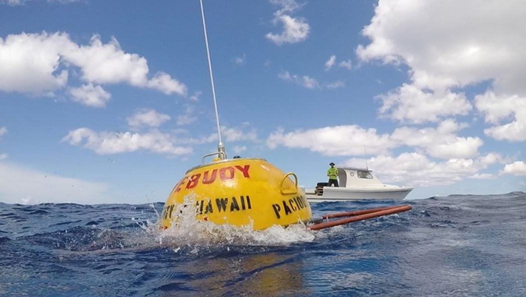
NOAA's October 2026 ocean-observing update highlights new buoys in Palau and Mississippi Sound, giving leisure boaters practical ways to compare live wave readings with forecasts.
Small-boat decisions are often made from a mixture of weather forecasts, local advice and a glance at the water from the shore. NOAA's October 2026 Integrated Ocean Observing System newsletter draws attention to a useful extra source of evidence: new wave buoys reporting actual conditions in Palau and Mississippi Sound. Both deployments bring additional measurements to areas used by local coastal communities, including recreational boaters who need to judge wind, waves and the limits of sheltered water.
The update identifies a new Ngaraard buoy off Babeldaob in Palau and two Sofar Spotter buoys installed by Mississippi State University near Gulfport and Biloxi. These stations report several characteristics of the sea rather than simply a single wave-height figure. Understanding what those readings mean—and what they cannot tell you—can make a pre-departure check more useful than blindly following an app's forecast icon.
New observations in very different waters
The October IOOS newsletter describes a wave buoy deployed off Ngaraard on the northeast coast of Babeldaob, Palau. The Coral Reef Research Foundation helped with deployment through the Pacific Islands Ocean Observing System, or PacIOOS. NOAA says the instrument collects wave height, direction and period alongside sea-surface currents, sea-surface temperature and air temperature. Those observations are valuable in a region where coral-fringed passages and exposed approaches can look deceptively inviting from shore, particularly when the wind near a departure point does not reflect swell arriving from farther offshore.
The same bulletin reports that Mississippi State University has installed two Sofar Spotter buoys in Mississippi Sound near Gulfport and Biloxi. They report wave height, direction and period as well as water temperature and atmospheric pressure. NOAA says observations are already being collected consistently and made publicly accessible through GCOOS and the Backyard Buoys app. For a skipper using the northern Gulf's inshore routes, data from within the Sound can contribute a more locally relevant picture than relying solely on a distant offshore forecast point.
Understanding the three wave readings
Wave height is the number most people notice first, but it cannot describe an entire day's sea conditions on its own. Direction indicates where the waves are arriving from, helping a boat owner consider whether a chosen route or harbour entrance will be exposed. Wave period—the time between successive wave crests—provides another clue to the character of the sea. A longer-period swell can remain substantial even when local wind has eased, while shorter, steep waves may make a relatively modest height feel uncomfortable in a small boat.
These data do not provide a simple traffic-light verdict about whether it is safe to depart. A buoy measures conditions at its location; waves change as they enter shallower water, bend around headlands or reflect from structures. A reef passage, river mouth or marina approach can behave differently from the open-water monitoring site. Treat wave observations as one piece of a route-planning picture alongside weather forecasts, tidal information, charts, notices to mariners and the actual limitations of the boat and crew.
Why extra locations make a difference
A single offshore buoy may be excellent for tracking a broad weather system but less precise about how it is developing inside a bay. Additional sensors create opportunities to compare conditions between points and assess whether wave energy is changing along a planned route. In a large area such as Mississippi Sound, that can be useful to small-boat operators moving between launch ramps, barrier islands and sheltered inlets. It can also help coastal authorities and researchers understand local conditions over time, rather than inferring everything from stations many miles away.
The new sites sit within a much larger observing network. NOAA's October newsletter says more than 600 assets report wave data across the Integrated Ocean Observing System, which supports navigation, forecasting, port operations and coastal hazard planning. That is a reminder of the hidden infrastructure behind apparently simple marine information. Sensors need secure moorings, calibration, communications systems, maintenance visits and arrangements for turning raw readings into information people can interpret. Better coverage depends as much on keeping instruments working as it does on putting new ones in the sea.
Checking measurements before leaving the dock
An easy pre-departure routine begins by deciding what kind of information is needed. If the concern is an exposed stretch, check a forecast for the route and then compare recent readings from the nearest relevant buoy. Look at more than a single observation: trends over several hours may reveal whether a swell is building or easing. Confirm the timestamp and station location before using any reading to make a decision, especially on websites and apps that combine many monitoring networks in one map.
While underway, do not assume an observation viewed at breakfast describes conditions later in the afternoon. Weather fronts, local sea breezes and changing tide streams can alter wave steepness and the ride quickly. On smaller craft, a cautious skipper keeps enough margin to turn back or choose sheltered water if what is actually encountered is worse than expected. If a buoy is temporarily offline or a value seems implausible, the absence of reassuring data is not evidence that the conditions are benign.
A particular benefit for island and nearshore trips
For leisure boating in Palau, direct knowledge of swell direction can be particularly useful when thinking about movement between open Pacific water and reef-protected lagoons. The Ngaraard buoy provides a new observation point on Babeldaob's northeastern side, but it should never replace local advice on reefs, channels or currents. Coral environments demand conservative navigation because depth and breaking-wave patterns can change sharply over short distances. A cautious passage plan must account for those hazards separately from whatever the wave buoy reports.
In Mississippi Sound, the considerations are different but equally practical. Shallow stretches, shoals and access channels make local wind and wave conditions highly relevant to dayboats, fishing craft and small sailing vessels. Information from the two Spotter buoys can supplement the official coastal waters forecast when planning a trip among launch sites and barrier islands. It is also worthwhile to check waterway restrictions and any local notices, particularly when travelling near working ports or unfamiliar inlets.
Using data well is a boating skill
Wave data is increasingly easy to find, yet good judgement remains indispensable. Learn where a monitoring point actually sits and which variables it measures, rather than relying on a colour on a smartphone map. Understand the difference between a measured condition, a forecast and an app's interpretation of either. Keep a copy of the latest official marine forecast and the navigation information required for the area. When connectivity is poor, electronic convenience can disappear just when conditions become more difficult.
The new Palau and Mississippi installations highlight the value of practical ocean science to ordinary recreation. Their biggest promise is not a guarantee of calm water; it is additional evidence that can help people decide when to go, which route to take and when to stay ashore. NOAA's publicly described observing work links local partnerships with a national system, making the results accessible well beyond the scientists who maintain the equipment. For a family preparing a coastal day trip, that is an improvement worth understanding and using responsibly.