
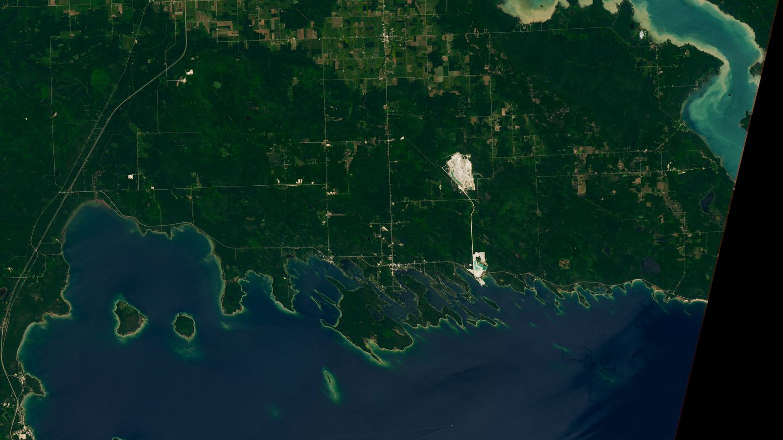
A richly illustrated boating guide to Lake Huron’s Les Cheneaux Islands, from NASA’s July 2026 satellite view to Hessel's wooden-boat tradition, conservation and practical cruising.
A chain of islands shaped for unhurried cruising
At the northern end of Lake Huron, Michigan's Les Cheneaux Islands form a coastal puzzle of wooded shores, curved bays and sheltered-looking channels. The archipelago lies along the Upper Peninsula about 20 miles northeast of the Straits of Mackinac. From the water, it is a destination made for modest ambitions: a slow run between islands, a quiet fishing stop, an afternoon in a waterfront town and enough time to appreciate the craftsmanship of local wooden boats. It is not the place to test how fast a powerboat can cover distance.
The region takes its name from the French expression associated with channels, a wonderfully apt description when looking down on the islands. NASA's Earth Observatory highlighted the area in August 2026 using a Landsat 9 view taken on 23 July, capturing the extraordinary parallel lines of the island chain. An image from orbit makes the pattern easy to understand, but a helmsman on the water still needs current charts, local notices and a properly planned track; the picture is a geographic portrait, not navigational advice.
What the latest satellite image actually reveals
NASA describes 36 islands grouped along roughly 12 miles of Michigan shoreline. Their elongated forms are glacial landforms, including many drumlins left when ice moved across the region during the Wisconsin glaciation. Shallow water appears comparatively bright in satellite imagery, while strips of land show forest cover, beaches and wetland edges. That mix explains why a trip here feels different from a cruise along one uninterrupted coast: a passage may be open and exposed in one direction, enclosed by trees in another.
Crews will recognise the two sides of that geography. The scenery creates comfortable places to pause, fish and explore, yet numerous islands do not guarantee deep water or a clear route between them. Submerged rocks, shoals and changing conditions can make an apparently direct shortcut unsuitable for a specific vessel. The responsible approach is to study official charts for Lake Huron, check current navigational notices and have a local harbour contact ready. Use NASA's image to enjoy the story of the coast, not to decide where to point the bow.
Hessel: a waterfront with wooden-boat heritage
Hessel is one of the names visitors will encounter when planning shore time. Its docks and waterfront are closely associated with the annual Les Cheneaux Islands Antique Wooden Boat Show, which began in 1978. According to the Les Cheneaux Historical Association, the event now brings together roughly 150 antique and classic boats supported by more than 300 volunteers. The 2026 show took place on 8 August, so an October visitor should enjoy the heritage year-round rather than expect the show to be in progress.
Classic runabouts carry a particular emotional weight here. They are working examples of how pleasure boating developed around Great Lakes summers: varnished wood, carefully maintained engines and family boats built to run between shore cottages. The association records that E.J. Mertaugh Boat Works was an early Chris-Craft dealership beyond the company's Algonac home base. That connection gives the islands an industrial as well as scenic history, worth appreciating whether the vessel arriving today is a small fibreglass cabin cruiser or a restored mahogany runabout.
Cedarville: the other half of the shore visit
Nearby Cedarville adds a contrasting stop and hosts the Les Cheneaux Historical Association's Historical Museum and Maritime Museum. The association exists to preserve the area's social, maritime and natural history, so a shore excursion here provides context for the islands seen on the way. The exhibits and local programmes are especially interesting to people who like to understand what made a waterfront community thrive rather than merely photograph the skyline.
Boaters planning to visit by water should verify the actual marina, transient-dock arrangements and any shore transport before setting a course. A town's presence on a map does not mean every dock is public or available to visiting vessels, and seasonal services can change quickly once summer ends. Anyone trailering a boat will also need to confirm launching, parking and retrieval procedures with the chosen operator. Treat Cedarville and Hessel as complementary points of interest, but make the practical arrangements through the facilities that will actually serve the boat.
The case for a small, slow dayboat itinerary
A compact dayboat or comfortable trailerable cabin cruiser is well suited to seeing a limited stretch of the archipelago when weather allows. A satisfying itinerary might involve an early start, one carefully navigated channel, a quiet lunch aboard and a booked shore stop near a community harbour. The driver avoids pressure to cover every island, and passengers can notice cedar trees, marsh edges and differences in light across the water. A sensible day ends with a fuel margin, spare time for recovery and an option to return before conditions worsen.
For families, the attraction is choice. Some might prefer a short run followed by a museum visit, while keen anglers choose a lawful fishing outing in waters appropriate to their skill and boat. Others will be happiest with a camera, binoculars and the pleasure of being on the water. Every version should begin by choosing a suitable legal launch, checking navigation and weather, and making the destination fit the crew's abilities. The quieter day is often the one that leaves everyone eager to return.
Fishing and the varied freshwater environment
NASA notes the archipelago's sheltered waters support recreational fishing, including species such as smallmouth bass, northern pike, yellow perch and lake trout. That range reflects the complex meeting of protected nearshore habitats with larger Lake Huron waters. It should not be treated as a guarantee that every species is present or legally available at every spot. Fishing seasons, limits, protected areas and licensing are governed by the relevant Michigan authorities and must be checked for the date and precise water being fished.
The habitats deserve care even when no rods are aboard. NASA identifies marshes, sandy and rocky beaches, peat bogs and mixed pine-cedar forest, while portions of several islands are reserved for conservation. Avoid assuming an attractive strip of shoreline permits landing, camping or anchoring. Some land is privately owned and some is protected; boater courtesy includes checking access rights, reducing wake in narrow waters and keeping clear of sensitive shallows. Wildlife viewing is most rewarding when it happens without pressing close enough to change an animal's behaviour.
From glacial ice to a modern cruising map
The distinctive elongated islands are not accidental. During the last ice age, moving glaciers shaped the region and left ridges and mounds whose orientation is evident in NASA's 2026 image. The agency places the retreat of the relevant Wisconsin ice around 10,000 years ago. Looking at the alignment before departure can make the coastline much more legible, although the visible patterns do not indicate the depth of nearby channels or the strength of a wind-driven current.
The larger land history is even older. NASA describes bedrock dominated by dolomite, formed from material laid down more than 400 million years ago when the region occupied a different latitude and marine environment. The nearby quarries visible from space are reminders that this is a working landscape as well as a holiday coast. For a family travelling with curious children, the story connects what they can see—parallel islands, pale rocky shores, forest and the occasional quarry—to a geological journey on a scale far beyond any weekend.
Why boat-show day is different from an ordinary weekend
The Les Cheneaux Antique Wooden Boat Show is an annual highlight, but it alters how a visitor should plan. The historical association lists Hessel's waterfront as the show venue and describes a major gathering of classic boats and volunteers, accompanied by associated arts and heritage activity. A skipper arriving during a future edition should expect the harbour environment and any temporary marine restrictions to differ from a normal Saturday. The event date, berthing advice and local navigation measures should be verified with organisers and authorities before departure.
In 2026 the event marked a century of Century Boats, a theme that suited the area's enthusiasm for traditional construction. Visitors who came in August could see restorations, boat-handling traditions and crafts that do not depend on owning a rare classic. For an autumn cruise, however, the show is an excellent reason to research the destination, not a live attraction. The museums and boatbuilding legacy remain the core of the story, and the quiet waters provide their own experience beyond the festival.
Weather, navigation and the return trip
Lake Huron is not a pond simply because an island blocks the view of the horizon. Wind across the Great Lakes can create difficult wave conditions, and a sheltered channel can end abruptly near an exposed reach. Check the National Weather Service marine forecast and observations relevant to the intended route, consider gusts and any hazardous conditions, and establish a turn-back point while the crew is still comfortable. A destination that looks idyllic in August can be demanding in October, when daylight is shorter and water is cold.
Plan for changing visibility, cold-water consequences and equipment failures. Life jackets, communications, navigation backups and an honest assessment of fuel and engine condition matter more than stylish equipment. Keep speed suitable for tight waterways and other water users, avoid unnecessary wake and give conservation shorelines room. A boat operator unfamiliar with the islands should consider local guidance or a professionally skippered trip. A single genuinely safe and interesting harbour call is worth more than an ambitious loop rushed against the weather.
Where to look for reliable local detail
The most useful reading combines different kinds of official knowledge. NASA's 2026 Earth Observatory feature explains the terrain and the newly captured satellite image. The Les Cheneaux Historical Association provides primary information on the boat show, maritime museums and local heritage, while the Les Cheneaux Chamber of Commerce gives community event information. Those sources tell you why the area matters; they do not replace charts, harbour instructions or marine forecasts.
Before booking accommodation or launching, confirm with the harbour or marina exactly where visitors can berth and what services will be available during the intended dates. Check Michigan Department of Natural Resources information for protected lands and current fishing rules, and consult the current official charts and Coast Guard notices applicable to the intended route. If a planned shore stop is unavailable, change the itinerary early rather than reaching a private dock after dark. In the islands, preparation keeps leisure leisurely.
A quieter way to appreciate the islands
Les Cheneaux rewards curiosity. One crew may return for the August wooden-boat spectacle, another for the small-town museums, and another to understand why glacial ice produced such a strange chain of parallel islands. For the leisure boater, the signature experience is the scale: large enough to offer variety, compact enough to encourage a slower day and full of shoreline details that disappear at high speed.
The best trip combines respect for protected habitats with the pleasure of classic boating. Use an appropriate vessel, choose an accessible and lawful stopping place, allow time ashore, and leave enough daylight for the journey back. The satellite image can show the larger pattern, the local museums can explain the people who lived and worked here, and a quiet passage through the channels can supply the memory that neither a picture nor a map can provide.