
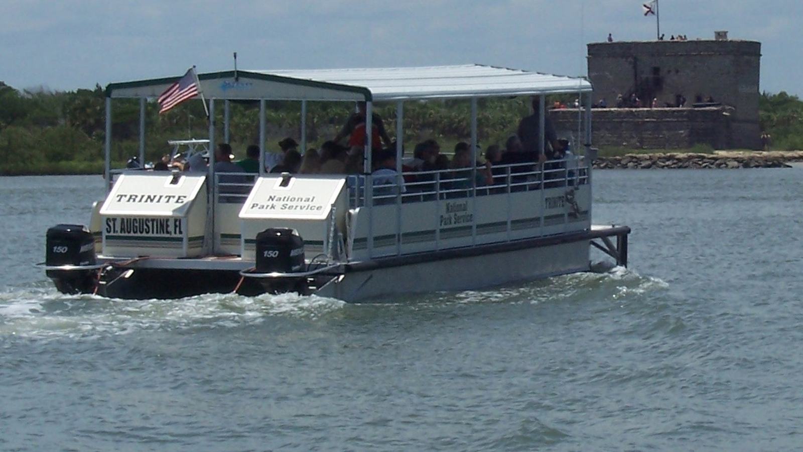
An informed guide to Fort Matanzas National Monument, the official passenger-ferry crossing, the Spanish watchtower and the surrounding coastal waters south of St Augustine.
A short crossing with a long memory
Fort Matanzas is the sort of coastal stop that changes the way a small-boat traveller reads an inlet. South of St Augustine, an unusually compact Spanish stone fort stands amid tidal water and low vegetation, reminding modern visitors that waterways were once both transport routes and vulnerable approaches to settlements. The best way to appreciate its setting is to give the river time, rather than treating the fort as an isolated monument.
Visitors should understand the access arrangements before leaving home: the National Park Service operates the passenger ferry that connects its visitor centre with the fort. This is a managed heritage experience, not a place where recreational boaters should plan an independent landing at the fort. A short official crossing offers a close look at the landscape while keeping the historic structure and its sensitive surroundings protected.
The fort sits in a broader coastal environment shaped by the Atlantic, Matanzas Inlet and the Intracoastal Waterway. That combination makes it compelling to boat owners who enjoy maritime history as much as destination cruising. A successful day may pair the ranger-led crossing with time on the mainland trails and a considered look at the waterways, without improvising access or navigation near the monument.
Why a small fort guarded a vital route
The Spanish settlement at St Augustine was defended by the much larger Castillo de San Marcos, yet its southern water approaches created a strategic problem. A vessel entering by Matanzas Inlet might reach the settlement from a direction the principal fortress could not fully control. Wooden watchtowers had watched this approach for generations, but the humid coastal climate and attacks made a more durable defence desirable.
Construction of the stone tower began in 1740, with coquina quarried locally and foundations prepared for difficult marshy ground. The work was complete by 1742, and the new fort helped deter a renewed British threat at the inlet. Its modest dimensions are part of the story: a carefully sited fortification could hold strategic significance without the monumental footprint associated with Europe’s great citadels.
Coquina is an evocative building material for anyone familiar with Florida’s shore. Made from compacted shell fragments, it binds the structure visually to the coast it was intended to guard. At the fort, masonry, gun positions and a raised outlook make more sense when viewed in relation to the surrounding water, especially the passages and shallows that historically governed where ships could safely move.
Plan the ferry rather than the shortcut
The visitor centre is at 8635 A1A South, about fourteen miles south of St Augustine. The park states that admission and its passenger ferry are free, but every passenger, including infants, needs a same-day boarding pass collected in person from the Fort Matanzas Visitor Center. Passes are issued on a first-come, first-served basis, and the limited-capacity trips can fill early.
As published by the park for the current operating pattern, ferry service runs Thursday through Monday and does not operate on Tuesdays or Wednesdays. Weather and other operational conditions can interrupt crossings, so check the park’s current alerts and hours on the day of travel. If the fort crossing is the heart of your outing, arriving early is an important part of the plan rather than a minor convenience.
The National Park Service describes a ferry visit of roughly forty-five to fifty-five minutes, including time at the fort. Treat that as a guided encounter with a historic site, not as transport for a free-ranging island excursion. The visitor centre dock, nature trail and boat are accessible, but stairs at the fort itself limit access to the historic structure; the park provides specific accessibility guidance for visitors who need it.
Read the water as a working landscape
Seen from the ferry, the island and riverbanks reveal why the fortified lookout mattered. Channel direction, open water, exposed shores and tidal edges are not simply scenic details: they are clues to the decisions made by earlier navigators and defenders. Even a short crossing can prompt questions about the relationship between coastal geography and the location of a settlement or watchtower.
Today's waterways also carry recreational traffic, working boats and wildlife. The monument is surrounded by the Atlantic Ocean, the Matanzas River, the inlet, the Summer Haven River and sections of the Intracoastal Waterway. A visitor who already cruises these waters can use the fort as a starting point for understanding their history, while still checking current charts, local notices and conditions separately for any independent boating.
Avoid treating the historic fort as a convenient place to beach a dinghy or step ashore from a private vessel. The park directs visitors to its own ferry service for access, and that route is designed around the protected site. For the independent boater, respecting that distinction is part of good seamanship: historic access, wildlife habitat and private cruising plans should never be confused.
Make time for the visitor-centre shore
The shoreline around the visitor centre is more than a waiting room for the ferry. The park offers nature trails, a picnic area, fishing access and opportunities to look across tidal scenery while considering how the landscape has changed over time. Families can gain a rewarding half day even when a ferry crossing is unavailable because of the day of the week or unsafe weather.
Footwear matters here as much as it does aboard a boat. Comfortable shoes with secure soles are sensible for paths and for the fort’s steps, while sun protection, water and a light layer help in exposed or changeable conditions. The park warns against unsuitable loose footwear on the fort’s stairs and ladder; climbing a historic structure is quite different from strolling a level museum gallery.
Parking is limited, particularly on busy days, and the park does not accommodate oversized vehicles in its constrained lot. If travelling by road, allow margin for that limitation rather than aiming for the final minute before a tour. If touring from a vessel based farther along the coast, arrange shore transport thoughtfully and avoid assuming that the National Park Service has a marina or overnight berth at the monument.
A place for anglers, with boundaries
The monument’s waters offer another perspective on a living coastal environment. The park identifies species including red drum, sheepshead, black drum, spotted seatrout, bluefish and flounder, and explains that fishing is possible in permitted areas. That does not make every bank, boardwalk or dock available to anglers, nor does a fishing stop supersede the purpose of a protected historic site.
Florida saltwater licensing and applicable regulations still matter, and the park lists additional local restrictions. Fishing is prohibited from park boardwalks and docks, and from certain shoreline areas near the fort docks; collecting plants and animals within park boundaries is also restricted. Read the National Park Service fishing guidance alongside current Florida rules rather than relying on generic advice for the Intracoastal Waterway.
Manatees and dolphins may occur in these waters, and the park specifically advises boaters to slow to idle if marine mammals are observed and not to approach them. For recreational skippers, that advice reinforces an important difference between navigating a busy coastal route and moving through a protected landscape. Leave room for wildlife, avoid disturbance and keep the visit focused on observation.
The history is richer than a photograph
An attractive ferry image conveys the atmosphere, but the fort's past is more complex than a picturesque ruin. The National Park Service also interprets the much earlier violence that gave Matanzas its name, including the killing of French colonists in 1565. Visitors should make room for that difficult history rather than reducing the site to a romantic story of stone walls and cannon.
The fort’s later military role reflects changing empires, technologies and coastal priorities. Its placement demonstrates how an apparently minor waterway can have outsized importance in a defence network. For anyone who enjoys pilot books, old charts or the history of coastal trade, the visit adds a human dimension to features that might otherwise appear as simple lines of land and water on a chart.
Walk around the visitor centre and listen to the ranger interpretation with the same curiosity you would bring to a vessel’s design. Ask why the tower stands in this particular spot, how supplies reached it and what its garrison could realistically accomplish. The answers connect construction, navigation and the everyday lives of the people assigned to this remote watch post.
A sensible coastal-day itinerary
Begin by checking the monument’s current operating notice and deciding whether a ferry crossing is practical for your travel date. Arrive at the correct visitor centre early, secure boarding passes for the entire party and use any waiting time to explore the mainland shore. Take the ferry only when the park is operating it and follow ranger guidance at the fort.
After the crossing, allow time for the local habitat and historical displays rather than racing on to another attraction. A relaxed visit lets the fort's small scale become an advantage: from one position, you can imagine the approach of vessels, the work of soldiers and the conditions faced by crews sailing the inlet. The experience is particularly satisfying when the river itself becomes the main subject.
Before setting out on any separate cruise in the wider Matanzas and St Augustine area, consult up-to-date nautical charts, weather, tides and local guidance; conditions at inlets and shoals cannot be inferred from a sightseeing article. The official ferry is the reliable access method for the monument, while recreational boating remains a distinct undertaking requiring proper local navigation planning. Fort Matanzas rewards both interests without blurring their boundaries.