
A hands-on Lake Superior cruising guide for cabin-boat owners, explaining Apostle Islands docks, anchoring, marine weather, lighthouse visits and mainland support.
A fresh-water cruising destination with a serious horizon
Off Wisconsin’s Bayfield Peninsula, the Apostle Islands offer a very different kind of recreational boating holiday. Forested islands, red sandstone shores, historic lighthouse stations and a web of sheltered-looking passages create the outline of an easy cruise. Yet this is Lake Superior, where cold water and fast-changing weather can give a short trip offshore the seriousness of a much longer voyage.
For an owner of a cabin cruiser or modest motor yacht, the real appeal is the ability to explore several places at an unhurried pace while keeping a mainland base within reach. The National Park Service manages twenty-one of the islands as Apostle Islands National Lakeshore, with Madeline Island outside the national lakeshore. Knowing that distinction helps a skipper understand that rules and facilities are not necessarily identical across the whole archipelago.
Begin with Bayfield and a realistic cruising radius
Bayfield provides an obvious place to organise a trip, with marinas and shore-side services along the mainland. The Park Service also identifies boating access from places including Washburn, Red Cliff, Cornucopia and Little Sand Bay. A practical itinerary should start with the boat’s fuel range, available berths and reliable weather outlook, not with a list of every island that looks close on a small-scale map.
A small cruiser might spend its first day exploring a nearby island and return to a known marina before dark, then expand its radius as conditions permit. A more capable vessel can stay longer in a suitable anchorage, but shelter changes with the wind direction and may deteriorate quickly. Lake Superior rewards conservatism, particularly when an apparently calm morning precedes a front that makes a planned return uncomfortable or unsafe.
Park docks are useful but cannot be assumed
The National Park Service lists public docks on a number of the islands, including Basswood, Raspberry, Oak, Rocky, Sand and Stockton. Many are modest structures with reported depth ranges of only two to seven feet in their most usable sections, depending on the location. Those published figures are indicative rather than a hydrographic guarantee; changing lake levels, sediment and storms can alter a landing considerably.
A skipper should review the specific dock, the boat’s draft and the expected water conditions before committing to an approach. Some dock areas are reserved for Park Service operations or commercial excursion traffic, and the remaining public space is generally first come, first served. That makes an alternative anchoring or return plan essential, especially during popular summer weekends.
Anchoring is an active task on Lake Superior
The Park Service warns that vessels are driven aground at anchor in the Apostle Islands each year. It recommends finding the lee of an island, monitoring changing conditions and setting a scope appropriate to the depth between deck and lakebed. The park’s guidance describes a minimum anchor-line scope of seven times that distance, and it advises an anchor watch when adverse weather threatens.
An anchor light is required from sunset to sunrise, and the crew must keep clear of docks, harbour approaches and shoal water. Modern chartplotters and drag alarms are valuable aids, but they cannot replace a properly set anchor and a watch that understands the forecast. A skipper who is unsure about bottom holding or a narrowing weather window may be better served by a secure mainland berth.
Why the lighthouses matter
The islands have a remarkable collection of historic lights, originally intended to guide vessels through the hazards of Lake Superior. Raspberry Island, Michigan Island, Sand Island, Outer Island and Devils Island help tell the region’s maritime story, though access and tour schedules vary by site and season. These are not merely scenic buildings in a holiday photograph: they are reminders of why mariners needed dependable navigation marks here in the first place.
A worthwhile shore programme might combine one accessible lighthouse visit with a short walk, time spent interpreting the island’s history and a relaxed return to the boat. It is better to learn which sites are open on the day than to promise visitors entrance to every tower. Landing at a historic island remains subject to dock conditions and park restrictions, even if a lighthouse is plainly visible from the water.
Sandstone caves deserve distance and judgement
The sculpted cliffs and sea caves are among the Apostle Islands’ signature sights. From a cabin cruiser they are best appreciated at a carefully selected, safe distance, particularly where shallow rock, reflections and wave surge complicate the approach. A large wake or changing swell can turn a photogenic section of shoreline into a poor place to hold position.
Kayaks may visit some coastal formations when conditions are appropriate, but their operating limits and risks are very different from those of a powered cruiser. The skipper should avoid following paddlers into water that is too shallow or constrained for the boat, and should leave plenty of room for human-powered craft. Every photograph is optional; maintaining safe separation from rock and other visitors is not.
Cold water changes the emergency calculation
Lake Superior remains cold even when the air feels summery. The Park Service notes that water in May and June can remain in the 40s Fahrenheit, while squalls and heavy seas can develop quickly. A boater should therefore plan for immersion, delayed recovery and communications difficulties rather than relying on the distance to the nearest town as proof that help will be immediate.
Personal flotation devices should be readily available and worn when circumstances call for them, especially on tenders and open decks. The vessel needs suitable emergency communications, reliable navigation lights, an informed passenger briefing and a way to reboard someone from the water. The National Park Service recommends VHF radio because mobile service can be limited; Channel 16 remains a key emergency contact for the Coast Guard and park rangers.
Fuel, repairs and provisions belong ashore
Apostle Islands National Lakeshore has no commercial fuelling or boat-repair facilities within the park. The Park Service lists mainland and nearby marina locations where boaters can obtain fuel, including Bayfield, Washburn and other communities along the peninsula and around Madeline Island. For a multiday trip, the captain must decide the fuel reserve before leaving shore and resist the temptation to stretch it simply because the next island is visible.
Provisions and freshwater deserve similar attention. A family cruise with children is more enjoyable when extra layers, warm food and dry clothing are already aboard. Boaters should plan any shore waste disposal and overnight arrangements in advance, treating island facilities as limited and seasonal rather than a substitute for an equipped marina.
Stockton and Raspberry offer contrasting experiences
Stockton Island is a useful example of why a planned stop should have a specific purpose. Its Presque Isle area appears on Park Service charts and lists of public docks, creating opportunities for a visit when suitable space and weather coincide. A woodland walk and beach experience may be more rewarding than repeatedly shifting an anchor in pursuit of a postcard view.
Raspberry Island offers a different chapter, built around a historic light station and a connection to the region’s navigation heritage. A skipper should verify tour availability and landing access directly with the park and avoid assuming that published summer services operate every day. Visiting one site well is often preferable to rushing between both when the breeze is building.
Build a two- or three-day plan with escape options
A sound short itinerary begins with a mainland marina, a favourable forecast and one attainable island stop, with an alternative that brings the boat safely home. On a subsequent day, the crew can consider a longer run toward another lighthouse or a protected bay only if winds, visibility and dock availability support it. Any itinerary presented to guests should clearly separate intended destinations from guaranteed arrangements.
The safest cruising plan also has a decision time, after which the skipper heads for shelter rather than attempting one more island. Sudden thunderstorms, fog and short steep seas are not remote possibilities in the park’s own description of the lake. A recreational voyage should preserve enough margin to enjoy the islands, not simply survive the passage.
Seeing the islands without disturbing them
The archipelago’s wildlife, beaches and historic sites are part of a protected landscape. Boaters should observe applicable park rules, control noise and wakes near others, avoid sensitive shorelines and take all waste away. Shore visits should respect trails, any posted closures and other people’s expectation of quiet in a national lakeshore.
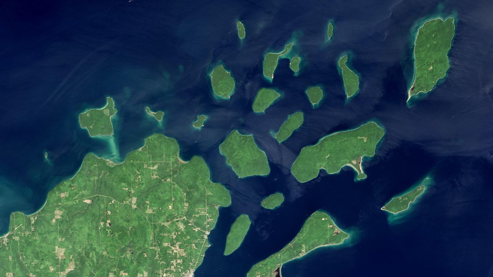
The accompanying image comes from NASA Earth Observatory’s Landsat observation of the islands in August 2015. It illustrates the archipelago’s geography, not present-day shoals, weather or navigational depth. For a current passage, the Park Service’s boating instructions, up-to-date nautical charts and marine forecasts are the essential sources to consult before casting off.