
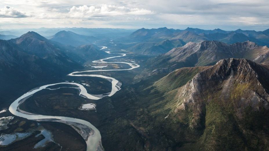
The Alatna River runs from Arctic mountain lakes past the Arrigetch Peaks, offering extraordinary wilderness rafting. Its distance from roads and difficult headwaters demand a self-reliant crew.
A wild river surrounded by mountains
The Alatna River begins among lakes and mountains near the Arctic Divide and travels approximately 145 miles southeast towards the Koyukuk River. Around 83 miles of its length lie within Gates of the Arctic National Park and Preserve. This is not a launch-and-return outing with roadside services; it is a true wilderness journey through the Brooks Range. Broad mountain views and a changing valley are the attraction for capable rafters prepared for genuine isolation.
The National Park Service draws attention to the Arrigetch Peaks, dramatic granite formations rising above the valley, and the striking contrast between alpine tundra, snowy mountains and riverbank vegetation. Part of the route provides access to demanding hiking and mountain climbing terrain. Those landscapes can tempt travellers to plan many excursions from camp, but side trips consume time and energy that the river expedition must already allow for.
The corridor is also a landscape of human history. NPS records identify it as traditional hunting territory of the Koyukon Athabaskan people and connect Nunamiut heritage with its upper reaches. Thousands of years of occupation are reflected in archaeological sites. Visitors should treat the entire route as a living cultural landscape, leave archaeological material where it lies and avoid presenting wilderness as a place untouched by the people who know it best.
The upper river deserves a careful assessment
The agency describes roughly the first twenty-five miles from the headwater lakes as rocky and potentially shallow. In low water a party using Summit Lake may need to portage for several miles, while lining boats over awkward stretches can be unavoidable. This is a substantial burden with loaded rafts and expedition supplies. The scenic promise of an upper-lake starting point should therefore be weighed against how much slow, exposed work the crew can safely undertake.
For approximately the first forty miles, the river can carry faster currents and rapids before widening and generally becoming calmer farther downstream. Above Ram Creek, class III whitewater is possible. Labels like class III describe difficulty in broad terms and cannot guarantee a consistent route, particularly where water volume, obstructions and local channels change. River competence, appropriate equipment and a willingness to scout are prerequisites for an upper-river journey.
Lower, wider sections may offer a less forceful float, but that does not turn the Alatna into a beginner’s recreational paddling venue. Access, cold weather, navigation, communications and potential medical evacuation remain demanding across the corridor. Plan for the experience of the weakest group member as well as its strongest. A conservative start point and itinerary are better than an ambitious launch followed by unexpected portages and a missed aircraft pickup.
Aircraft logistics and remote safety
Access typically involves floatplanes to places such as Circle Lake, Summit Lake or Takahula Lake, or bush-plane services based around Bettles. Charter availability, weather and allowable loads are critical details to confirm with the actual operator. The park’s broad descriptions should not be mistaken for a promise that every possible aircraft landing is serviceable today. The raft, paddles and provisions must all fit within the transport plan, and return arrangements need realistic buffer time.
An isolated Alaskan river demands dry protective clothing, reliable personal flotation devices, a suitable craft and the capability to repair it. Carry navigation maps independent of a single electronic device, a satellite communication method, first aid and food for delays. Even in warmer weather, cold water and mountain weather can make immersion dangerous. Everyone in the party should understand group rescue procedures and the implications of losing a boat or critical bag far from assistance.
Wildlife observations can include caribou and other northern animals, but they should be made at a distance. Camp hygiene and bear-aware food storage are essential in this environment. Keep campsites small, protect fragile vegetation and plan the disposal of all waste before entering the park. Because local rescue resources may be distant, leave a detailed route and check-in plan with a reliable contact and make the timing of overdue reporting unambiguous.
Let the river dictate the pace
A sound Alatna plan begins with a clear assessment of whether the upper reaches are worth the additional difficulty for this particular crew. The most famous scenery is not necessarily the safest location to launch, and photographs of placid downstream water cannot describe the obstacles near the lakes. Consider the time needed for portages, any intended hiking and a margin for weather that may delay aircraft operations. The point is to finish with energy and flexibility to spare.
Seek current information from Gates of the Arctic staff and the charter operator, including water conditions, landing constraints and the feasibility of the selected take-out. The park’s river description provides a useful landscape-level briefing, but a real expedition requires more than a web-page map. Ask what has changed recently, whether the chosen craft is appropriate and what alternatives exist if a planned landing or portion of the river becomes unsafe.
For an experienced party, the Alatna combines geology, wildlife, mountain scenery and one of the strongest senses of remoteness available on a river expedition. Respect for that remoteness is the condition of enjoying it. Prepare for uncertain water, travel light enough for the aircraft, carry robust emergency systems and remain willing to change plans. This Arctic route should be approached as a serious wilderness undertaking, never as an ordinary summer day afloat.
Primary planning source: National Park Service Gates of the Arctic Alatna River. Consult the original National Park Service guidance and current notices before departure.